Bike Ride North from the Neponset Trail
1:00 pm, Sunday, September 25, 2022
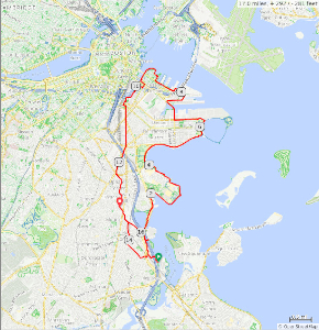
Every once in a while we check out where the Neponset Trail is and will
be going north from its current terminus at Tenean Beach in the Port
Norfolk section of Dorchester, following the route it will eventually
take to Columbia Point. We'll pick up the existing trail around Columbia
Point past Carson Beach to Castle Island.
We'll ride on the new mixed-use path along First Street in South Boston and take Summer St. into the Seaport District. We'll pick up the South Bay Harbor Trail at the ICA and follow it to Dorchester Ave which we'll take to Boston Ave to Edward Everett Square. We'll follow back streets south to a brief stretch of Dorchester Ave, then zigzag across southern Dorchester back to Tenean Beach, with a stop at Phillips Candies for those who are interested.
Helmets are required. Heavy rain will postpone the ride. Bring a mask if you wish to wear one when inside a building or close to others.

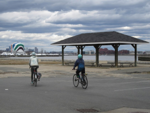
Bikes headed north from Tenean Beach
Details
- Where: Meet at the parking lot at Tenean Beach.
- When: Departing at 1:00 pm, Sunday, September 25, 2022
- Distance: about 15 miles.
- Pace: Relaxed, probably 6-10 MPH.
- Terrain: Mostly flat.
- Route: Mixture of shared-use path (50%) and roads (many with bike lanes)
- Leader: Jessica Mink
Maps and Cue sheet
- Printable map and altitude profile (1.05Mb PDF file)
- Cue sheet only
- Map and altitude profile: (PDF)
- Ride With GPS map

Getting There
Bicycle
From the south, cross the Hancock St. Bridge from Quincy and turn right into Port Norfolk.From the north, take Dorchester Ave. to Freeport St. and follow it to Conley St., where you turn leftand go under the Southeast Expressway to Tenean Beach.
From the west, take the Neponset Trail
MBTA
You can take your bike on the Red Line to the Savin Hill stop for no extra charge. Take Savin Hill Ave west to Dorchester Ave, then turn left on Freeport Ave to Conley to Tenean Beach. Details are on the MBTA website.Car
From the north, take the Southeast Expressway to the Gallivan Blvd/Neponset Circle exit, go around Neponset Circle to northbound Morrissey Blvd, and turn right onto Conley St and under the Expressway to Tenean Beach.From the south, exit the Southeast Expressway onto northbound Granite Ave toward Neponset Circle, which you will reach by turning right onto Gallivan Boulevard. Go around the Circle to northbound Morrissey Blvd, and turn right onto Conley St and under the Expressway to Tenean Beach.

Click for Google Maps